Select NOAA-NWS Forecast Office Text Products

(Product availability varies with seasons, forecast office, and weather.)

Hazardous Weather Outlook for Binghamton, NY

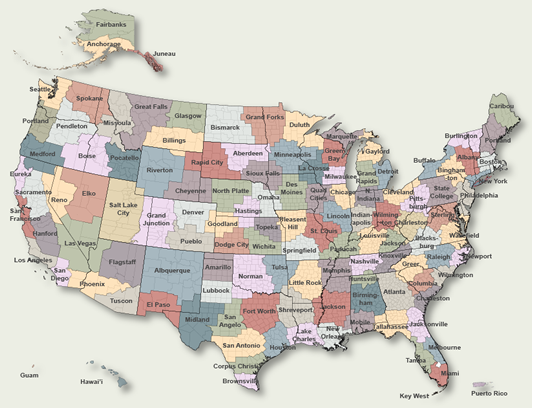
To Select Another NWS Office Click on Map or Choose from List

County Warning Area MAP
Select Forecast Office:   Select Product:  
629
FLUS41 KBGM 251947
HWOBGM

Hazardous Weather Outlook
National Weather Service Binghamton NY
247 PM EST Sat Jan 25 2025

NYZ015>018-022>025-036-037-044>046-055>057-262000-
Yates-Seneca-Southern Cayuga-Onondaga-Steuben-Schuyler-Chemung-
Tompkins-Madison-Southern Oneida-Cortland-Chenango-Otsego-Tioga-
Broome-Delaware-
247 PM EST Sat Jan 25 2025

This Hazardous Weather Outlook is for central New York.

.DAY ONE...Tonight.

Hazardous weather is not expected at this time.

.DAYS TWO THROUGH SEVEN...Sunday through Friday.

A period of high winds with gusts 40 to 50 mph are possible late
Monday night and Tuesday morning before an Arctic front passes south
of the region. The winds will be strongest over the northern Finger
Lakes region to Syracuse, Utica and Rome areas. The gusty winds
could cause scattered power outages.

Snow squalls also will be possible in central NY Tuesday morning as
this Arctic front moves south of the region. Brief periods of heavy
snow, blowing snow and very low visibility with gusty winds will be
possible. Persons traveling Tuesday morning should listen for further
updates on this snow squall potential. Travel could be impacted.

.SPOTTER INFORMATION STATEMENT...

Spotter activation is not expected at this time.

$$

NYZ009-262000-
Northern Oneida-
247 PM EST Sat Jan 25 2025

...WINTER WEATHER ADVISORY REMAINS IN EFFECT FROM 1 AM SUNDAY TO
1 AM EST MONDAY...

This Hazardous Weather Outlook is for central New York.

.DAY ONE...Tonight.

Please listen to NOAA Weather Radio or go to weather.gov on the
Internet for more information about the following hazards.

   Winter Weather Advisory.

.DAYS TWO THROUGH SEVEN...Sunday through Friday.

Please listen to NOAA Weather Radio or go to weather.gov on the
Internet for more information about the following hazards.

   Winter Weather Advisory.

.SPOTTER INFORMATION STATEMENT...

Weather spotters are encouraged to report significant weather
conditions according to Standard Operating Procedures. Please relay
any information about severe weather to the NWS.

$$

NYZ062-PAZ038>040-043-044-047-048-072-262000-
Sullivan-Bradford-Susquehanna-Northern Wayne-Wyoming-Lackawanna-
Luzerne-Pike-Southern Wayne-
247 PM EST Sat Jan 25 2025

This Hazardous Weather Outlook is for central New York and
northeast Pennsylvania.

.DAY ONE...Tonight.

No hazardous weather is expected at this time.

.DAYS TWO THROUGH SEVEN...Sunday through Friday.

No hazardous weather is expected at this time.

.SPOTTER INFORMATION STATEMENT...

Spotter activation is not expected at this time.

$$
NICOSIA

Previous Hazardous Weather Outlooks may be found at
NWS Binghamton, NY (BGM) Office Hazardous Weather Outlooks.
(Click 'Previous Version' there to view past versions successively.
Some may differ only in time posted.)

San Juan, PRHonolulu, HI Lake Charles, LA Pueblo, CO Corpus Christi, TX St. Louis, MO Reno, NV Raleigh, NC  Newport/Morehead City, NC Dodge City, KS Houston/Galveston, TX San Joaquin Valley/Hanford, CA Louisville, KY Fort Worth, TX Pittsburgh, PA Austin/San Antonio, TX Sacramento, CA Jackson, MS Phoenix, AZ Northern Indiana, IN Flagstaff, AZ Tallahassee, FL Springfield, MO Riverton, WY Blacksburg, VA Sioux Falls, SD El Paso Area, NM Columbia, SC Wilmington, NC Greenville-Spartanburg, SC Eureka, CA Midland/Odessa, TX Tucson, AZ Goodland, KS Huntsville, AL Amarillo, TX Norman, OK Lubbock, TX Marquette, MI Little Rock, AR Pendleton, OR Missoula, MT Binghamton, NY Boston, MA Green Bay, WI Billings, MT Baltimore/Washington San Diego, CA Tampa Bay, FL Morristown, TN Twin Cities, MN Brownsville, TX Portland, OR Des Moines, IA Memphis, TN Pocatello, ID San Angelo, TX Jacksonville, FL Aberdeen, SD Quad Cities, IA/IL Charleston, SC New Orleans/Baton Rouge, LA Peachtree City, GA Shreveport, LA Grand Rapids, MI Medford, OR Albany, NY Wichita, KS Gray/Portland, ME Spokane, WA Boise, ID Denver/Boulder, CO Great Falls, MT Caribou, ME Key West, FL Miami-South Florida, FL New York City/Upton, NY Melbourne, FL Hastings, NE Paducah, KY Glasgow, MT Bismarck, ND Charleston WV Omaha/Valley, NE Buffalo, NY Jackson, KY Kansas City/Pleasant Hill, MO Gaylord, MI Cheyenne, WY Grand Forks, ND Detroit/Pontiac, MI Central Illinois, IL Burlington, VT Salt Lake City, UT Topeka, KS Nashville, TN Milwaukee/Sullivan, WI Albuquerque, NM Las Vegas, NV Wakefield, VA La Crosse, WI Birmingham, AL Los Angeles/Oxnard, CA Chicago, IL Seattle, WA Rapid City, SD Indianapolis, IN Philadelphia/Mount Holly, PA Mobile/Pensacola State College, PA Cleveland, OH Elko, NV Wilmington, OH Grand Junction, CO North Platte, NE Tulsa, OK San Francisco/Monterey Bay Area, CA Duluth, MN Anchorage, AK Fairbanks, AK Juneau, AK Tiyan, GU

Products Courtesy of NOAA-NWS
NWS Information Parsing Script by Ken True at Saratoga Weather - WFO and Products Scripts by SE Lincoln Weather.
Mapping by Curly at Michiana Weather and by Tom at My Mishawaka Weather.